1. Introduction
The city is studied as a social, cultural and economical phenomenon. Moreover, the city is a spatial phenomenon in viewpoint of its arrangement and dwellings as well as city environment formation. Herewith, the structure fixed by plans and maps makes the city a promising object to study many factors including population distribution. We are interested in the social topography of Siberian cities at the turn of the 20th century that is understood as the influence of social set-up and status, employment and wealth on the city space formation (Richer 2015). An optimum tool to reconstruct the social space is a geographic information system allowing one to integrate data of different sources. Since the project's idea was to create an online interactive map of Siberian cities' social topography, one of the central goals was to synchronize data on different time periods and inter alia spatially identify city buildings both on historical plans and modern cartographic resources (Bryukhanova 2021).
The report will present approaches to spatial identification of city buildings used to create a historical web-GIS covering topography of Siberian cities at the turn of the 20th Century (Tobolsk Case).
2. Studies
The creation of cartographic online resources by means of comparing historical and modern data has been characteristic of some projects. For instance, projects based on cadastral information about property owners in such cities as Antwerpen (Center 2016) and Kazan (Johnson 2017) as well as Tartu (Rahvusarhiiv 2018) population census data.
One can hardly name any Russian online projects of the kind. The comparison of time different data in Russia was made when creating online maps of historical and cultural heritage (Suvorov 2014).
The problems and solutions related to identification of objects on historical maps can be found in works by C. Gordon (Gordon 2011), E. Diamond (Diamond/ Bodenhamer 2001), I. Gregory (Gregory et al. 2001) etc.
3. Sources and Technologies
To reconstruct the social topography of Tobolsk at the turn of the 20th century several groups of sources were in focus. The main are the 1860 map of the city with later (allegedly 1890) corrections and census papers of the 1897 First General Population Census of the Russian Empire providing us not only with socio-demographical data but a place of residence and owners of buildings. An extra source is lists of households with plans of 1897 census enumeration districts, lists of historical and cultural heritage objects of Tuymenskaya Oblast with data on old buildings and their modern address, periodicals telling us about ruined buildings and structures as well as modern cartographic resources (Yandex.Map, OpenStreetMap, Sas.Planet).
The main tool used to create GIS is MapInfo software. Moreover, to solve some problems of the project other technologies were applied. For instance, to present historical maps within present-day coordinate system WGS84 ArcGIS software was used. The online version of the project was based on NextGIS platform.
4. Results
Identification of historical buildings is the search for their present location on the map, application of an ID and geographical coordinates. To reconstruct the social topography of Tobolsk at the turn of the 20th century one can divide city buildings into three groups:
1) Buildings which have been preserved up till now. These are churches, mosques, the convict prison, the gubernial museum, etc.
2) Buildings which have been recently lost, but still have the same address. For instance, the house at the intersection of Pyatnistkaya Street (present-day Mira Street) and Pochtovaya Street (present-day Ershova Street) where the well-known Mariya Ussakovskaya’s photo studio was located at the turn of the 20th century and that is now ruined, but the present-day map can identify coordinates of the former two-storied building.
3) Buildings which have been lost. This group is the most difficult as far as spatial identification is concerned mainly due to private shops, studios and houses rather than institutions.
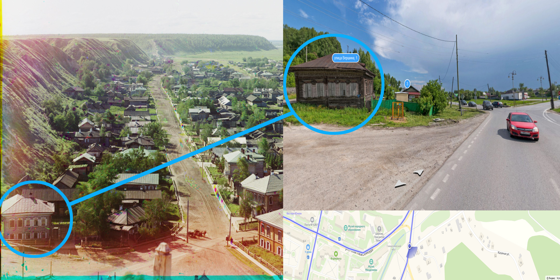
To identify the last group of buildings the authors apply extra cartographic, descriptive and photo sources. The most precise data on buildings can be found in the "List of householders" that has enumeration district plans with dwelling buildings. Unfortunately, there are data only on two parts of Tobolsk of four. Buildings of other parts can be reconstructed only partially. The preserved and identified buildings can be markers in this case. For instance, by comparing the historical and the modern maps the authors have found the coordinates of lost churches. An example here is Blagoveshchenskaya church that was located not far from Ussakovskaya’s house in Pyatnistkaya Street. When studying photos of Kuznetskaya Street (present-day Alyab’eva Street) made by Sergey Prokudin-Gorskiy in the early 20th century one can reconstruct the location of some dwelling houses, for instance, the house of a resigned civil servant Rozov and a petty bourgeois Blazhevitch. The location of some buildings (for instance, the house of the famous Siberian painter Mikhail Znamenskiy) has been found thanks to periodicals.
Particular difficulties are caused by buildings in the suburbs which nearly lack sources.
Thus, the authors have managed to reconstruct around 50% of city buildings in Tobolsk at the turn of the 20th century including state, public and religious institutions as well as private shops, dwelling buildings and other objects. The reconstruction technique was to compare time-different cartographic, nominative, descriptive and photo sources, indentify each building and fix its coordinates.
Figure 1. Comparison of photos of Kuznetskay Street in Tobolsk made by S.M. Prokudin-Gorskiy (beginning of XX c.) and provided by Yandex.Map resource
5. Acknowledgement
The study has got a grant support from the Russian Science Fund, project # 19-78-10020