1. Introduction
The advantage of bringing a geospatial dimension into research is already widely recognized as a very effective matter to analyse huge data repositories. Yet it remains challenging to geolocate a vast amount of data. This is especially the case for eastern Europe, where a considerable amount of populated places vanished or were renamed several times. Geolocation under such circumstances remains time intensive. Most research approaches did only look at gubernia or province level and did not go down to the level of populated places (Sablin et al. 2015). However, aggregated census-data have the considerable disadvantage, that is related to the borders, which changed often in the history of the Russian Empire and Soviet Union. This material keeps somehow very hard to be compared. Thus, a proper analysis of demographic and social change in this region would demand detailed geographic data for every single settlement in the area of interest. This paper proposes an automated approach to this geocoding challenge.
1.1. Gazetteers
There is no doubt that the choice of the gazetteer can fundamentally influence the search result. Search results can always be only as good as the chosen gazetteers were. There are some global gazetteers such as Geonames, which reach an impressive coverage, yet they do have often gaps concerning deserted towns or historic names. For this, specialized gazetteers like the historic gazetteer could offer better coverage, yet such gazetteers do not even closely reach the coverage of global ones. Thus if one wants to reach high generalizability, it’s inevitable to combine several different gazetteers. The Historic Place Name locator combines several different place name gazetteers. The most important are: Geonames, the historic Gazetteer (GOV), Wikidata and the Open Street Map (So far: Wikidata: www.wikidata.org , the Historic Gazetteer: www.gov.genealogy.net , Geonames: www.geonames.org and Osmnames, a gazetteer based on Open Street Map: osmnames.org . The combination of those different Databases to one common is documented here: https://github.com/erikradisch/historic-place-name-locator/tree/master/make-place-name-db ).
1.2. Search Algorithm
Historic place names do often appear in sources with spelling variations. Those outdated name variations do have a very little chance to appear in current gazetteers. Thus it is very important to implement a search algorithm, which can also deal with spelling variations. In the historic place name locator, a complex search routine consisting of three different similarity search algorithms is implemented. Two of them are the approximate string matching algorithms Damerau-Levenshtein (Damerau 1964) and Jaro-Winkler-Distances (Winkler 1990). The third one is a phonetic algorithm. Here, the user can choose between the Cologne Phonetics (Postel 1969) and Double Metaphone (Phillips 2000). Those three different algorithms enable the historic place name locator to even out spelling differences between historic sources and current gazetteers.
1.3. Historical Context
An important feature of the historic place name locator is its ability to include historic boundaries within the search. Search within its historical context is already performed in a few researches, however the overwhelming majority of historic projects do not have this advantage. The Edinburgh Geoparser ( http://groups.inf.ed.ac.uk/geoparser/documentation/v1.1/html/ ) does provide the possibility to focus the search on a special bounding box, yet those are very inaccurate. Our algorithm, the historic place name locator, solves this problem by including shape files of historic place names within the constructed gazetteer. There is a constantly growing number of professional Shapefiles of historic boundaries, which are available under open access. Some examples might be a map of all regions of Europe around 1900 (Mosaic), The Borders of the states of the German Empire (Mosaic, Harvard Geospatial Library), the Empire and Kingdom of Austria-Hungary (Mosaic) and the Russian Empire (Ristat).
The user only needs to connect the historic place names to the corresponding region in the shapefile by providing a second column with the naming of the regions from the shape file (needless to say, that this step gets unfortunately labor intensive, if a lot of places have different historic contexts). The algorithm thus favors results from this region. If the algorithm did not find a place in the historic region, it is possible to expand the search area step by step. For example, if a place might not be found in a historic region, a user can then let the algorithm search only in the whole country (in its historical borders) and at a third step in the whole world. Including a historical context can help to boost the accuracy of geo-referencing historic place names greatly as it helps to exclude possible hits which are more unlikely due to their location. As historic boundaries are very often highly complex an automated search algorithm has a real advantage here, as it is often hard to say for humans, where exactly a historic region ended and another one began.
1.4. Evaluation mode
The program has also an implemented evaluation mode, which enables the user to compare the matches to a gold standard. The algorithm produces html-files of differing results on which a map is seen with the historic border (if given), the gold standard (green) and the result of the algorithm (red) as will be shown at the conference.
1.5. The Russian Population Censuses Case
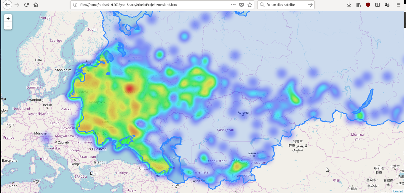
In Russian statistics, the most detailed and accessible data are presented in census materials. The first Russian population census of 1897 registered more than 49 thousand settlements, of them 870 cities and 966 more settlements with populations exceeding 5000 citizens each. We used the censuses data (of Russia in 1897 and of the USSR of 1959, and maybe the USSR census of 1926) as cases for testing the algorithm. A sample of several hundred randomly selected places were mapped manually to validate the algorithm success. The algorithm performed very well in geolocating these settlements (f-score above 0.9). This allows us to get a representative picture of the population distribution over the state territory as well as the urbanization map too. It also opens further research possibilities as this data can be easily connected to data from other sources, providing possibilities to geo-analyze historical data. The work also revealed some problems of automatic geolocation including problems of the quality of historical borders in vector maps. The presentation will propose strategies to avoid these problems.